
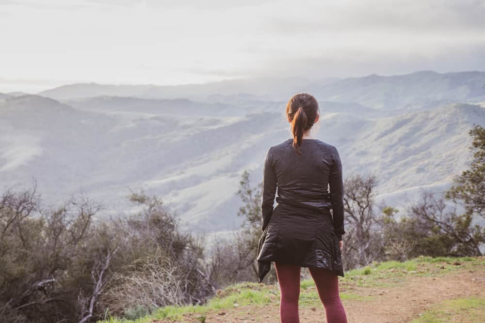
Hiking in Santa Barbara is a unique experience.
A small mountain range called the Transverse Range is just a few miles from the Pacific Ocean, creating a scenic mountain backdrop from anywhere in the city and meaning that countless Santa Barbara hikes are, literally, in your backyard!
It’s located just two hours north of Los Angeles and is the most southern part of Central California, bordering the northern part of southern California. This means the climate is just slightly cooler than L.A. and San Diego, making better hiking conditions, but it’s still warm enough to enjoy being outside all day.
The natural scenery tends to vary from oak woodlands, to sandstone peaks, to the Pacific Ocean.
While hiking in lower elevations, you’ll be rewarded with a nice sea breeze and views of the mountains themselves. While hiking up in the hills, you’ll get to enjoy the ocean in addition to what you’d expect to see in the mountains.
These are the six best hikes in Santa Barbara that encompass these beautiful natural features!
Easy Hikes Near Santa Barbara
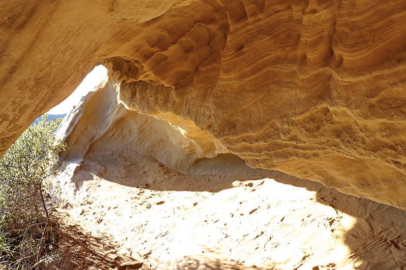
Gaviota Wind Caves
Note: This post contains affiliate links, which earn me a small commission at no extra cost to you if you make a purchase using one of these links. Thank you for supporting this free content!
Distance: 2.5 miles round trip
Elevation Gain: 600 feet
The hike to reach the Gaviota Wind Caves is a simple, enjoyable walk that is easily accessible from the Pacific Coast Highway. It’s located about 31 miles west of downtown Santa Barbara in Gaviota State Park
The first half of the trail is a paved road which eventually turns into a single track trail that heads north towards the caves. Once you reach the end of the trail, you will find many sandstone caves of varying sizes that have been carved out by the high winds that occur in the area.
These caves are fun to explore, as you can climb into them or scramble around the boulders that neighbor the caves. From the caves you will enjoy unobstructed views of the ocean along the Gaviota coast. This area of Santa Barbara is fairly undeveloped so you will be able to see great distances on clear days.
There are tons of local lizards and rabbits on this trail, and you may get to see red-tailed hawks, turkey vultures, cooper’s hawks, or other native predatory birds hunting throughout the hills.
The trailhead is only a few minutes walking distance from Gaviota State Beach, so this is a great place to hike on a hot day since you can cool off at the beach afterwards.
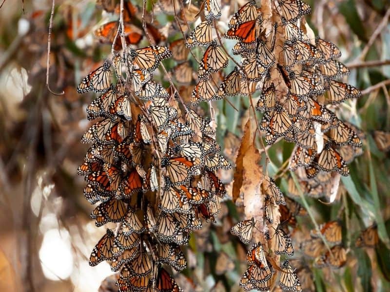
Ellwood Butterfly Grove
Distance: 1.2 mile loop
Elevation Gain: 62 feet
This trail takes you right along the coast and is a great way to explore terrain that is very characteristic of Santa Barbara. The Ellwood Preserve is a flat, open area over the bluffs of Goleta. It is right in the path of the monarch butterfly migration, so these orange butterflies populate the area over the winter months.
The path runs through a large field that contains beautiful wildflowers during the spring. There are great views of the ocean along the entire path, and there’s even a trail leading down to the beach from the top of the bluffs.
There is also a path that follows the edge of the bluffs along the entire length of the preserve, giving you multiple ways to extend your hike if you wish.
There’s not much shade on this trail, but there are eucalyptus groves bordering the preserve to the north and east if you are looking to cool down in the shade.
This also means there is not much to obstruct your view, so it offers great views of the Santa Ynez Mountains to the north of Santa Barbara as well as the ocean to the south. Visiting the preserve is an easy way to enjoy both of these unique features.
Moderate Hikes Near Santa Barbara
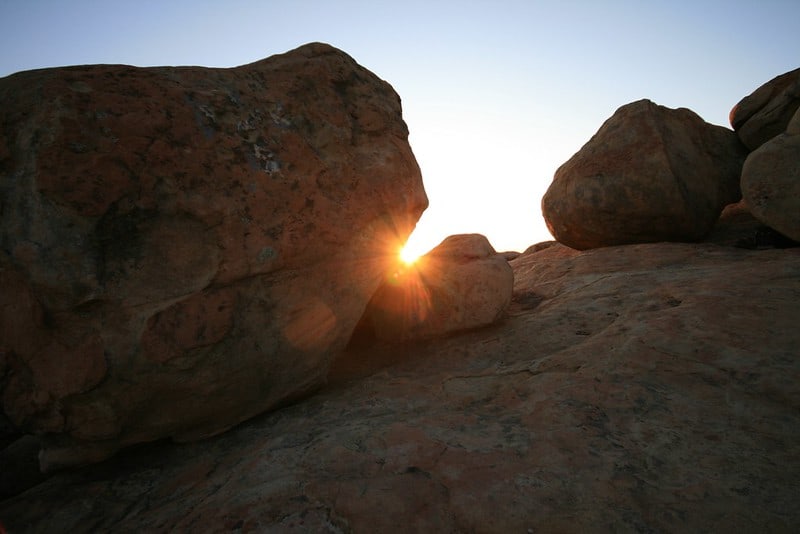
Lizard’s Mouth
Distance: 0.5 miles
Elevation gain: 25 feet
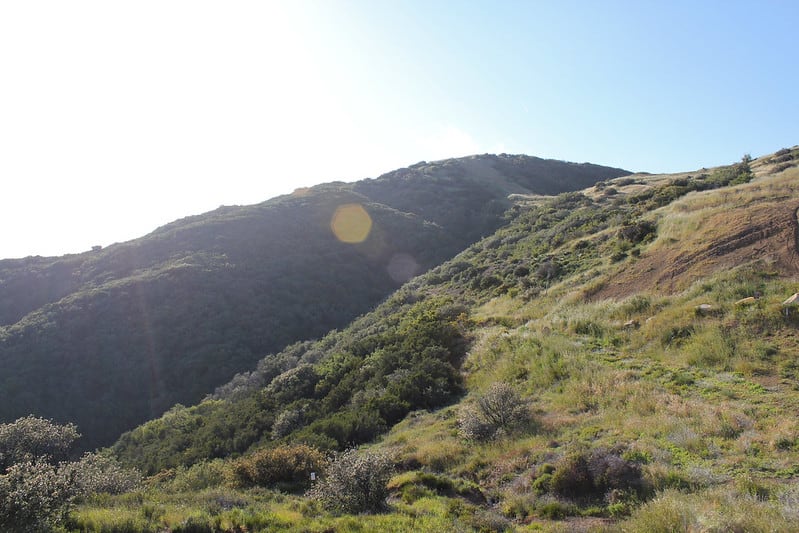
Lizard’s Mouth is a trail that is popular with both hikers and rock climbers. It’s located in the Los Padres National Forest in an open area with tons of large sandstone boulders. It’s a fun place to explore different bouldering routes, caves, and interesting rock formations. The end of the trail is a huge rock shaped like a lizard, but you don’t have to stop there if you want to continue exploring.
Lizard’s Mouth is directly above Goleta, and the view extends for miles in all directions. On a clear day you can easily see the Channel Islands, which lie about 30 miles south of Goleta. Due to the great views and easy access, this is a very popular area to watch the sunset!
While the hike is short with minimal elevation gain, there are some challenging aspects to it. It’s not marked, and there are many small trails that lead to the lizard rock.
Depending on the route you take you may have to scramble over some boulders. Many people enjoy this aspect of the hike since these are fun, easy rocks to climb over, and people often use this hike to scramble around the boulders in the area rather than find a specific point.
You can make this hike as long or short as you’d like. Regardless of how you choose to enjoy this area, you are guaranteed some amazing views of the California coastline on this beloved Santa Barbara hike.
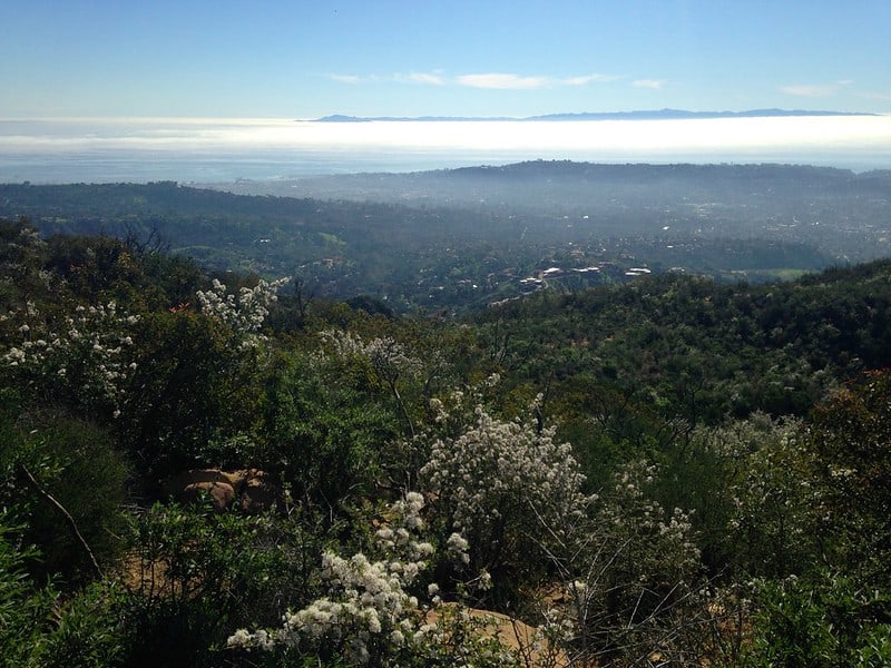
Inspiration Point
Distance: 3.5 miles
Elevation Gain: 950 feet
Inspiration Point is perfect for those looking for a moderate peak to bag in the Santa Ynez Mountains. The trailhead is located in the Los Padres National Forest in beautiful Mission Canyon, which houses tons of native plants, animals, and classic Santa Barbara scenery.
This first part of this hike follows a winding, paved fire road up into the canyon. Once the road ends, you want to take the wide, dirt path on the left that eventually turns into a single track trail.
After a few minutes, the path will cross Mission Creek, and you’ll reach another fork. The creek is dry most months of the year, but if you’re hiking after a bit of rain, you may be lucky enough to see it running. Stay towards the left, and the trail will be pretty straight forward to follow to the top.
As you gain elevation, the views keep getting better and better. Once you reach the top of your climb, you will be rewarded with the opportunity to gaze over all of downtown Santa Barbara, the vast Pacific behind it, and the sandstone peaks of the Santa Ynez that surround you.
Difficult Hikes Near Santa Barbara
Gaviota Peak
Distance: 6.5 mile loop
Elevation Gain: 2,150 feet
The Gaviota Peak hike is another spectacular trail in Gaviota State Park. This hike can be done as a loop by combining two trails: the traditional Gaviota Peak Trail and the Trespass Trail.
The traditional Gaviota Peak Trail is ideal for the ascent, since it has a bit more shade in the beginning. This path follows a dirt fire road that winds up and through the mountains of Gaviota and offers views of the hills to the north of the park. During winter and spring, these hills are luscious and green, and cows can be seen grazing in the area year-round.
Gaviota Peak is the highest peak in Gaviota State Park, so you can expect it’s going to offer amazing views, and you will not be disappointed after this challenging hike. As you arrive to the summit, you will enjoy 360-degree views of the ocean and surrounding mountains.
On a clear day, you may be able to see into the neighboring county, Ventura County, to the east, the Channel Islands to the south, and into the pristine, undeveloped Hollister Ranch towards the west.
Since the Trespass Trail is steep, it’s a nice route to take on the way down. The coast is visible almost the entire way back, rewarding you with great views for all your hard work!
Montecito Peak – West Fork
Distance: 7.6 miles
Elevation Gain: 2,444 feet
Those interested in peak bagging, sweet views, or a challenge should try the Montecito Peak hike. This hike is a consistent climb the entire way, but you will definitely be rewarded for your hard work.
If you take the West Fork, the first mile of your hike will be a bit more gradual than the rest of the hike, and will take you along the shaded, lush banks of Montecito Creek.
There are a few creek crossings, and then the trail starts to steepen. You will wind through the foothills of the Santa Ynez, and the views will change with each turn in the trail. Once you’ve gained enough elevation, the ocean will be a consistent part of the scenery, along with the surrounding peaks and foothills.
After you climb out of the shady, sycamore-dominated environment of Montecito Creek, the terrain transitions into a desert-like ecosystem filled with yucca plants, lightly colored sages, and very little to obstruct your view. The last portion of this tough Santa Barbara hike is steep, but once you get to the top you will see why it was worth the effort!
Pin These Hikes in Santa Barbara!


Allison Green is a travel blogger, writer, and podcaster who grew up in the Bay Area of California. She has spent time living in New York, Prague, and Sofia, but has returned to live in the East Bay. She has traveled to 60 countries before the age of 30 while running several digital travel publications. Her writing and podcast have been featured in Forbes, CBC Canada, National Geographic, the Huffington Post, and CNN Arabic, amongst others. She’s obsessed with bouldering, houseplants, other people’s pets, and anywhere she can see the ocean.